When I met my now husband – all the way back in 2003 – I was living on Rainey Street, Chermside; a suburb of Brisbane, Queensland, Australia.
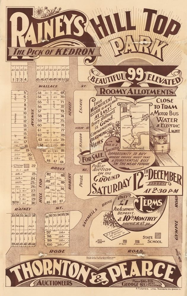
Today I found a cool real estate map from 1925 on the State Library of Queensland website of what was then named ‘Raineys Hill Top Park’ in Kedron.
Raineys Hill Top Park Estate, 1925
75 years later, I rented a flat built on Plot 30.
Although I can’t remember if it was ‘free from dust, and delightfully cool’ as advertised in newspapers at the time, it did have ‘water and electric light’. Unfortunately, I was too late to utilise the tram system which appears to have run along Gympie Road a few blocks away. (All Brisbane trams had stopped running by 1969.)
It was a lovely place to live and we have fond memories of our time there.
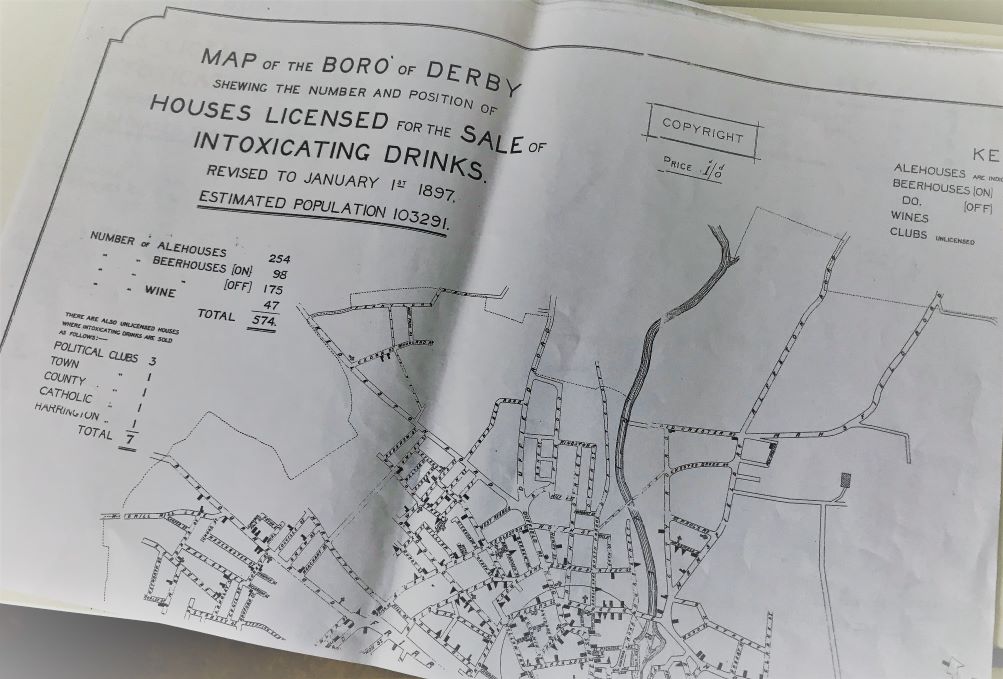
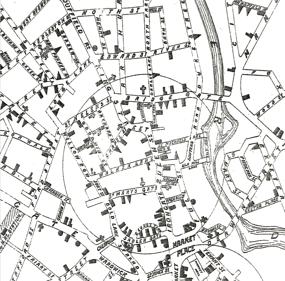
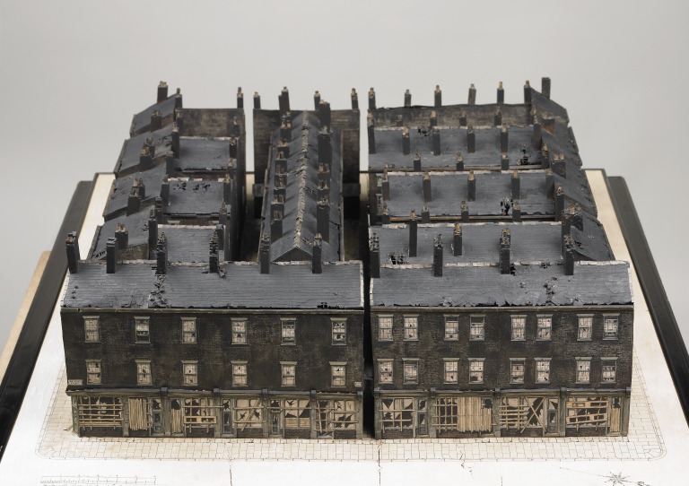
When visiting the Derby Local Studies and Family History Library, I happened to mention my interest in ‘The Shamrock‘ and the enormously helpful staff located a map out the back – Map of the Boro’ of Derby shewing the number and position of Houses Licensed for the Sale of Intoxicating Drinks.
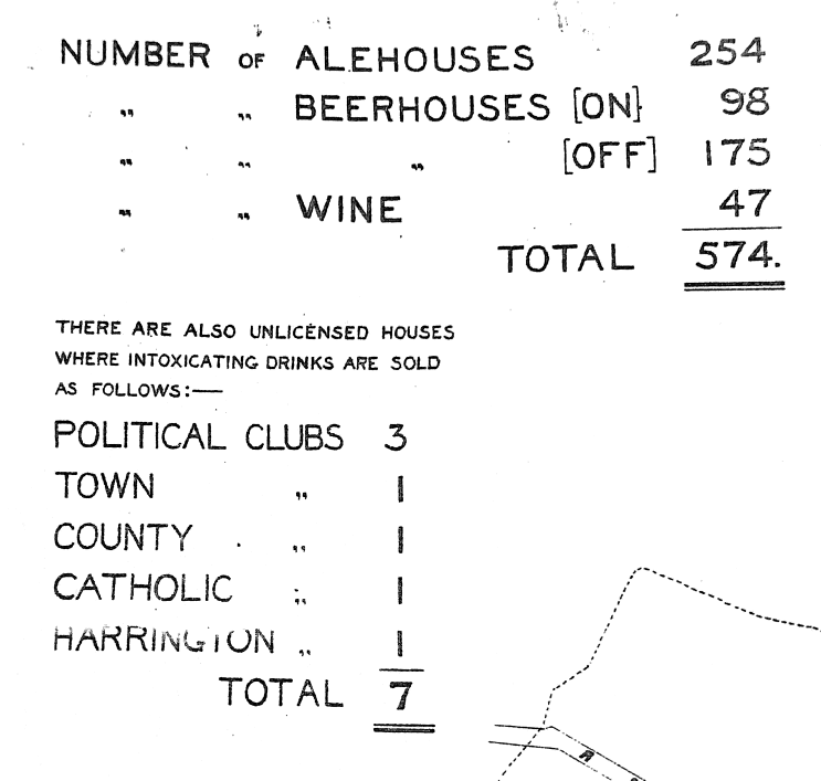
This map was produced seemingly to illustrate a problem. According to the figures, a total of 574 premises for a rather precise ‘estimated population’ of 103291 circa 1897, meant there was a licensed drinking house for roughly every 179 people. But not only does the map give me an insight to the lifestyle and issues of the area, it has also been helpful to pinpoint a more precise location for The Shamrock.
From research outlined in the previous post, The Shamrock was a licensed beerhouse located on Goodwin Street between 1857 and 1908. The map shows 5 establishments on Goodwin Street alone:
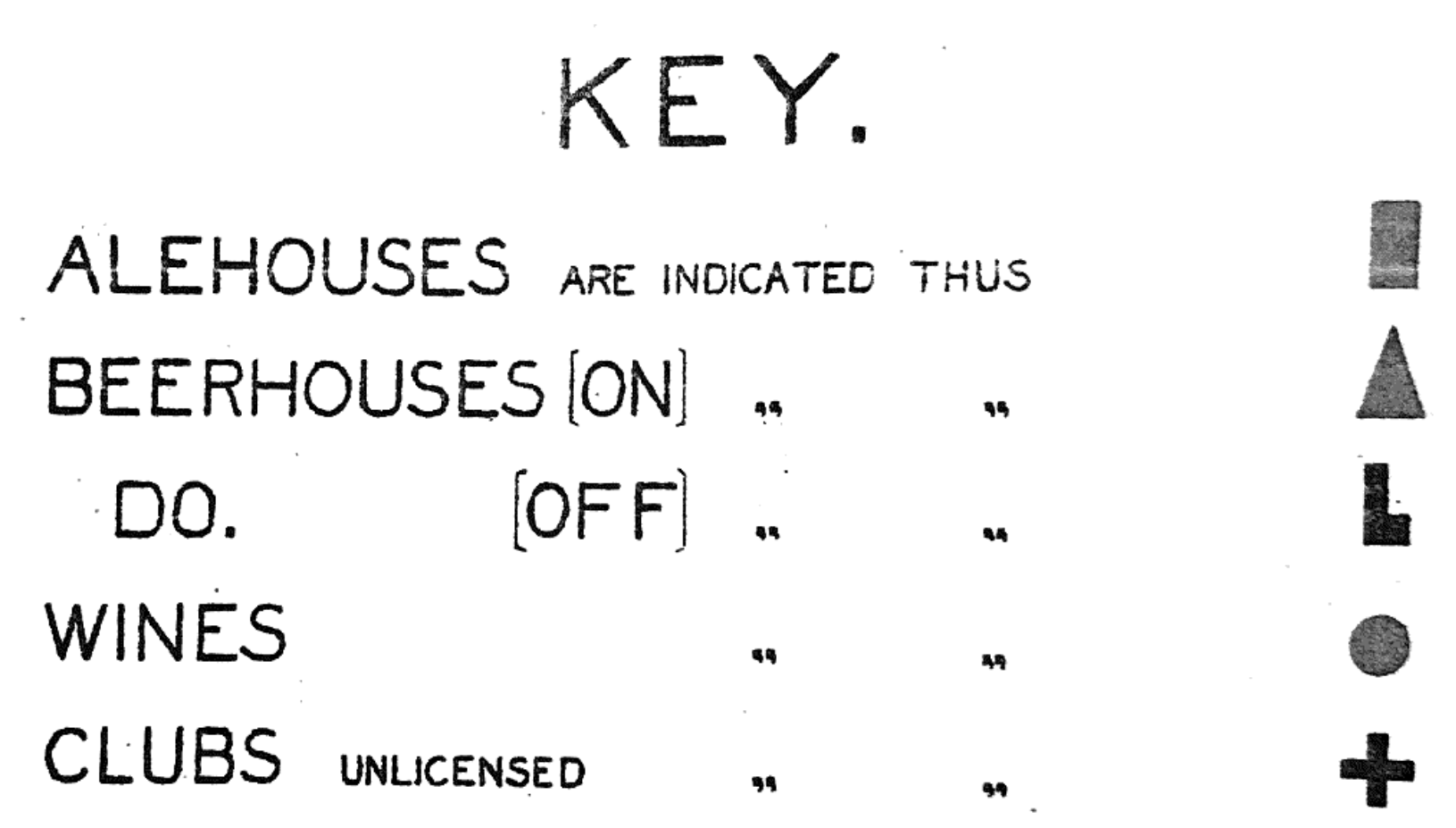
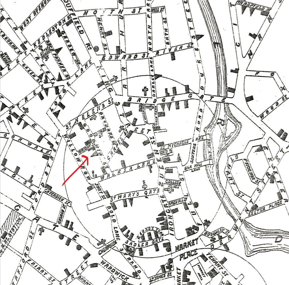
The key helpfully narrows things down by identifying each type of drinking house. Therefore, the location of The Shamrock must have been located at the triangle symbol:
The triangle symbol marks the likely location of The Shamrock
Unfortunately the area was demolished in the 1930s so I am unable to visit the actual building, but having this map somehow makes me feel a little better about that.
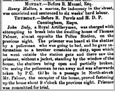
In my last post, I was trying to find a more exact address for Thomas Palmer, bookseller of Gosport. I had narrowed him down to ‘Upper South Street’ but not being a local, still had no idea where exactly upon the street he lived. The breakthrough came when I found a newspaper article reporting a robbery at his premises:
Portsmouth Times and Naval Gazette 22 November 1862, p8 c3
John Daly, a Royal Artilleryman, was charged with attempting to break into the dwelling house of Thomas Palmer, almost opposite the Police Station, on the previous night. The prisoner was heard at the shutter by a policeman who was going to bed, and he gave information to a brother constable on duty, upon which he went outside the station gate and there saw the prisoner, without a jacket, standing by the window of the house, the shutters being open and partially broken. On seeing the policeman he ran away and was afterwards taken by P.C. Gibbs in a passage in North-street. Mr. Palmer, the occupier of the house, proved fastening up the house about 9 o’clock the previous night. Prisoner was committed for trial.
The old police station in South Street, Gosport – 1949
So now I knew that he lived “…almost opposite the Police Station…”.
Unfortunately, the police station no longer exists on South Street after being destroyed by enemy action in 1941. I found a photograph of the building in 1949 on the Gosport Heritage site but it gave me no other details. Luckily however I found a c.1896 map which marked the location of the police station which made the description, ‘almost opposite’ make sense.
Location of Thomas Palmer’s book store in 1862 (map c. 1896)
Interestingly, there is also a photo on the Gosport Heritage site captioned; ‘Portland Place; south side of South Street, running north-south almost opposite to the OLD police station.’ I’m pretty sure Palmer’s old book shop is just out of shot on the far left of this image (behind the first building).
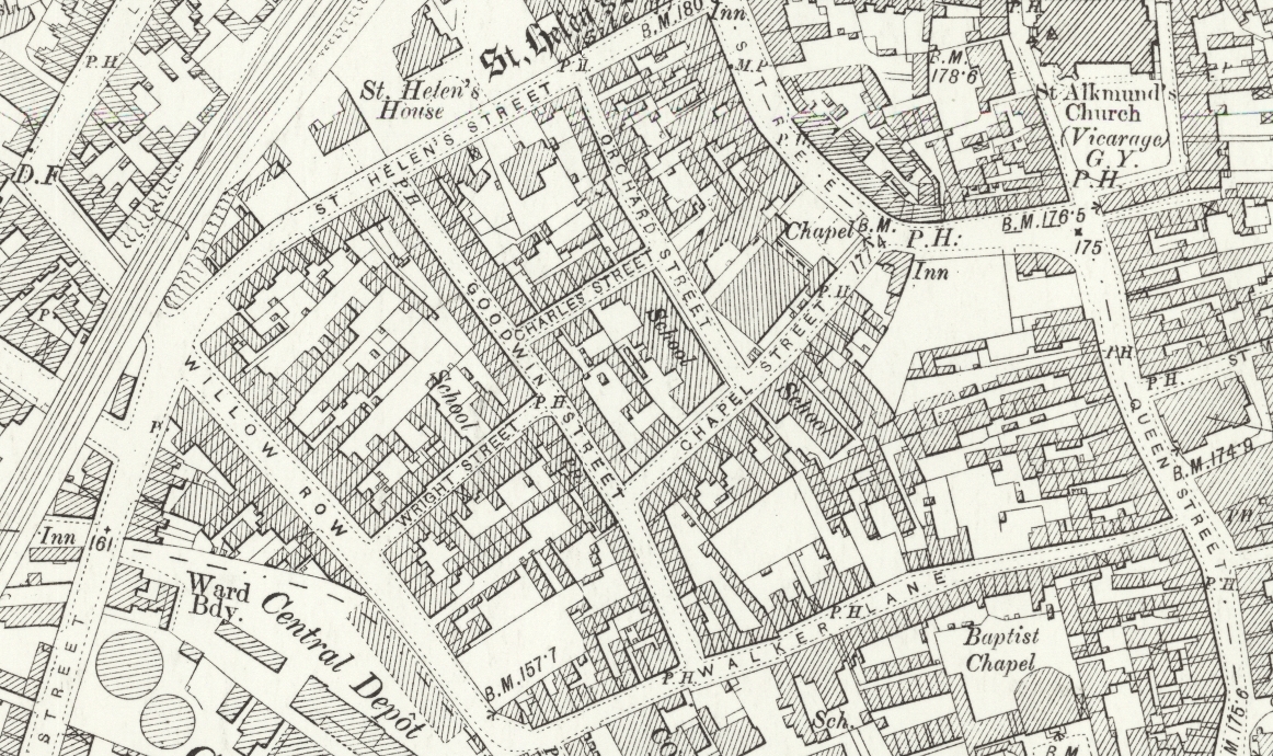
If you lived in the West End of Derby in the 19th century, you were considered to live in the slums. It is here that the families I’ve researched lived mainly in what was known as court housing (some more information on court housing here).
An article on the Derby Telegraph site mentions that this area was part of an 1849 report to the General Board of Health on “The Sewerage, Drainage and Supply of Water and the Sanitary Conditions of the Inhabitants of Derby”;
In Willow Row, Court 1, 103 inhabitants shared two privies and residents reported that milk would turn to curd when mixed with water from the communal pump…
Observations of Walker Lane, where 75 cases of typhus fever were reported between June 15 and September 14, 1847, were: “The houses are of the most inferior description and the inhabitants of a piece with their houses; to crown all, there are lodging houses, which are the principal headquarters of vagrants, and of those comers and goers who, for reasons best known to themselves, prefer darkness to light.”
It is in these conditions that Hannah Bates, William Lamb and their families lived most of their lives. The slum clearances of the 1930s mean that the court housing is now long gone but it’s important to keep these living conditions in mind when researching the people of the area and trying to understand their lives.
2016 map of Derby (black lines represent the old street layout)Circa 1899 map of Derby
Note: the Derby Telegraph article mentioned above is no longer available online [referred to: area-poverty-abounded-rich-community-spirit-pride/story-11591093-detail]
Applegarth Church, Dumfriesshire, Scotland via geograph
This is almost a continuation of my post about antenuptial fornication but I have decided to post separately as I am still not sure whether this is the same person.
In the Dumfries Kirk Sessions of 1822 (which are searchable online), James BROWN was “named as the father of Jean Smith’s child; [and] gave satisfaction for this in the parish of Applegarth” (Archive Ref: CH2/537/12). I believe ‘gave satisfaction’ (in this sense), meant that the father gave monetary compensation to the parish for their support of the child.
So was this James BROWN my ancestor, who appeared in the Dunscore parish records 6 years later for antenuptial fornication? With such a common name I cannot be sure but I can assess the likelihood of it being the same man for future reference.
First, was he old enough to be involved in this? Although I don’t have his birth record, the 1851 census suggests he was born in 1801, which means he would have been 21 at the time – a prime age for this kind of crime. 😉
James Brown and family on the 1851 census
(Interestingly, their neighbour, Andrew Lorimer (appearing at bottom of image above) was the certifying physician on James’ death certificate.)
Next, was he near enough to be involved? Applegarth is roughly 20 miles from Dunscore and about 30 miles from my James’ home, Glencairn. Not a short walk, but not impossible distances.
Map showing locations of Applegarth, Dunscore and Glencairn (Moniaive) in relation to each other via multimap
So I can’t rule out my James Brown as the father of Jean Smith’s illegitimate child and I have kept hold of this genealogical tidbit. To get any closer to proving this, I would need to check for further information in the Kirk Session records and the Applegarth parish records for any further information on Jean SMITH and her child.
Next Steps:
Check for further information in the Kirk Session records
Check Applegarth parish records for the child’s birth
Update: Checked Applegarth, Dunscore, Glencairn and Lochmaben parishes (via ScotlandsPeople) for any birth with Jean SMITH as parent (between 1800 – 1825) and any SMITH birth (between 1816 – 1825) – no likely entries found (all have listed fathers).